

We live by White Island in beautiful Escambia County on Pensacola Bay in the very toe of the boot of Florida (about 3 hours east of New Orleans) – Pensacola, the First City, the First Settlement in the New World, The Cradle of Naval Aviation, the Sailing Capitol of the World – Sailtown, USA – The home of the Blue Angels and American Magic – and sandy white beaches, White island, and emerald waters.

Unfortunately, ALL the public access, sandy beaches and waterline on Pensacola Bay have been bought up, turned into mansions, yacht clubs, country clubs, condos, and lined with rocks and piers – no safe areas for Kayakers, SUP, or small boats to land in an emergency. White Island is the last soft, sandy beach and island(s) in Pensacola Bay. But it may be destroyed any day! 😦

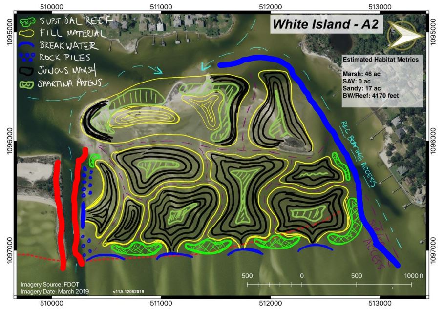
Construction has begun. Thousands of white plastic pvc poles demarcating the planned destruction and rock walls have been placed all around the island. Today may be her last day. Everything in black check pattern below is to be surrounded with turbidity curtains, chains, and dredged, killing everything that lives there, sullying the water, churning up decade old poisons, pollution, and toxins, huge barges and construction, then heaping all the dead dredged sand right on the animals that might still be alive on the two islands spared from the initial destruction.

When / IF a “restored” White Island emerges – after “425” Days (provided there’s no delays) and the dust settles, they’ll have created a literal moat and wall around the island, rock barriers, submerged reefs, invasive marsh blackneedle plants, and two kill-corridors of blind, rock lined, narrow fast boat access paths and eight new islands completely covered in marsh with no sandy beach or access… instead only a “managed recreational access” on the southernmost island.

White Island has always been a safe, natural, clean area for small unpowered boats, SUPS, kayaks, sailing dinghies, kids, and schools of tiny fish escaping the bigger fish, walking in the shallows with your family or sitting on the sandy beach, sheltered under the trees, in a hammock, or wading, swimming safe from fast boats with huge wakes or the bullsharks. This is precisely because it’s so shallow that the fast boats with big wakes avoid the northern side of White Island (by Davenport Bayou outlined in blue below) and it’s too shallow for sharks to sneak up on you. Over the decades thousands of families have camped out and welcomed the Blue Angels home as the island is right by the flightline on a winds from the west day – or watching American Magic foiling by. Now, this is to be made illegal. 😦
On the Southern side of White Island (by the Navy Channel to Bayou Grande shown in Red) There’s a nice wide channel (rocky on only one side) with sandy grade that small kayaks, sups, windsurfers, sailing dinghies from the Navy Morale, Welfare, Recreation MWR marina and surrounding community can escape a big, fast boat with wake coming through that channel.

(Red rock lined Navy channel and Blue New “Recreational Boat access”)
I’m very concerned that this White Island Restoration Plan calls for significantly narrowing both the north and south of White Island ingress/egress, creating a new “recreational boat access” (Blue) by dredging the northern area which will bring in fast boats, and adding rocks to create a bottleneck with blind turns with views obstructed by the rocks and new islands and creating a kill corridor lined with rocks on both sides of the southern Navy channel – leaving the small unpowered boats, sups, windsurf, sailing dinghies that may have to tack against the wind to navigate a very tight channel surrounded on both sides by rocks and currents with fast boats flying through. Many children enjoy this area and this seems needlessly dangerous. Literally placing the kids between waves and reefs, rocks, and fast boats 😦
Dredging and creating this new boat access (shown in blue ) will only invite fast boats into this area, the only safe place away from fast boats for kids and families. If the goal is to reduce erosion, preserve water quality, and provide for recreation – this blue path, if it absolutely must be dredged, should be a No Wake Zone – to prevent wake-based erosion and keep it safe for dolphins, children, families, and small unpowered craft. The fast, powered, big boats are able to use the red Navy channel to access White Island. No need for them to come up by the children and small unpowered craft in such a narrow, blind, rock-lined corridor.
There is no reason that the southern deep Navy channel (shown in red above and below) can’t be the sole recreational access for fast big powered boats, while preserving the blue area for small unpowered, sail, paddle, dinghy, SUP, kayak type craft, for swimmers, pets, and people walking amongst the islands. The concern is that the Navy channel will now be a narrow corridor lined with rocks on both sides (as seen above and below in red) and small unpowered/human/solar powered boats, sups, kayaks, windsurfers, sailing dinghies which may have to tack in this area to fight the current and wind now have no safe harbor or passage in and out of the bay and Bayou Davenport (Primary Kayak/SUP launch at Civitan Park) without great risk.
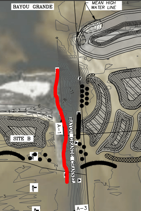
(Rocks to be on both sides of significantly narrowed Navy Channel to Bayou Grande – rockpiles and breakwaters on the right).
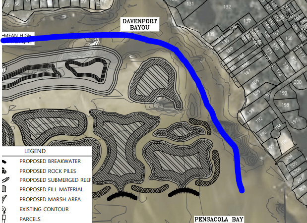
(New Northern “recreational boat access” lined by rocks, submerged reefs, marshes, blind corners, obstructed by new islands and marsh grass).
As a community, we feel misled. This was to protect recreation, stop erosion, and preserve the cleanliness of the water… but this new northern recreational boat access route with the dredging and being surrounded by rocks and reefs will make this significantly less safe for families and impede recreation. Now, we are finding out that the whole of North White island will be surrounded in invasive weeds, entirely blocking off the beach access. If a child has a boat failure or starts taking on water, or, god forbid, is hit by one of these fast boats coming in the new recreational motorboat access to the north, there will be no sandy, soft, safe beach for the child to swim to to avoid drowning or a sinking kayak.

(Northern White Island to be entirely surrounded by rocks, reefs, and marsh in yellow – removing all sandy beach access even on leeward side).
The beauty of White Island is being able to walk safely in crystal clear, shallow water, with white sand, for miles. But dredging between the islands now makes it deep, dark, and invites fast boats and sharks and precludes the ability for children to walk safely between the islands without fear of drowning or encountering fast boats, big wakes, or bullsharks. It seems, we can no longer camp out or bbq – now outlawed IN fLoRiDa!!!? – and that ONLY a “managed recreational access” will be provided? While the figures show a sandy beach on all the islands, it seems that an invasive marsh will be formed so people not only can’t walk between them, they can’t even walk or sit or land on them, even on the leeward sides as the marsh extends into the water and is known to be an invasive species known to grow out of control and clog drainage and kayak/sup access?
Our main concerns, in order, are (1) safety, (2) preservation of the cleanliness, nature, native species of the area, and (3) preserved free recreational access with soft landing spots in case of emergency. Please reconsider your support, and politely contact your representatives to reconsider or slightly modify the current plan of creating the new Davenport Northern recreational boat access (Blue above) and wholly blocking off the Northern White Island leeward side. Please ask them to also consider extending a No Wake Zone to preserve the safety, beauty, and small boat, family activities along the northern Davenport Bayou North White Island area.
This is the last of the sandy beaches and islands in Pensacola Bay safe for waders, swimmers, small sailing, human, or electric non-emission, no wake, exercise recreational activity. To kill everything in the kill zone, surround it in rocks, open up a superhighway dredged for big, fast boaters destroys the last of these safe nurseries, cradles of Naval sailing, SUP, Yakking in Pensacola Bay – the Sailing Capitol of the US and cradle of Naval Aviation / Sailing.

There just doesn’t seem to be a need for fast motored recreational boat access on both sides of White island. Recreational, powered, fast boats could use the Red, Southern Navy Channel, while preserving the Blue Northern Davenport area for unpowered, clean electric powered, human powered, swimmers, waders, kayaks, small SUP or sailing dinghy ingress and egress safely which also reduces erosion, promotes safety and recreational opportunities.
Consider a small rental sailing hobiecat or sunfish with US Navy / Airforce dependent children and families trying to tack a small boat without motor or oars UPwind / against the current through the Navy Channel to get to Pensacola Bay (Or coming home after a sail to Gulf Breeze or Maritime Park- while avoiding poles, markers, rocks, fast boats bidirectional traffic, wakes, waves, dolphins… This is about to become very dangerous. Especially with the new “!!!KEEP 500 feet away signs!!!” deployed at Magazine Point last week.

It is about to be spring break 2025 with Navy MWR marina sailboat, hobiecat, kayak, SUP, Sunfish rentals – those young servicemembers and their families and visiting friends trying to navigate upwind against the current out and trapped in the narrow rock-lined Navy Channel— are going to be severely at risk if they put up chains and turbidity curtains with all the thousands of PVC poles further restricting the width of the channel.
Even worse, from a safety perspective, for Navy sailors is that the roughly 3 miles of soft, safe sandy shore to land in an emergency on the sail to and from Fort Pickens will now be entirely blocked off by rocks, reefs, marshy islands with only tiny turbulent ingress/egress routes which will be impossible to navigate safely – especially with waves, wakes, squals, inevitable aging and equipment failures of sailboat / SUP / sunfish / hobie components, motors, sails, etc. If the White Island Restoration Living Shorelines project proceeds as-is it will put sailors, servicemembers, and their families, dependents, and children – as well as the broader community- at risk.
